It seems a bit strange to be “introducing the AFK” but this information was contained on a now redundant website and is no longer available for consultation. For the benefit of new readers (if there are any!) and as a reminder to others this is a (sadly) much abbreviated version of the history and geography of Altonia.
General setting.
The AFK is the Altonia Ferovojoj Komplementaj, or Complementary Railways of Altonia, to give the English translation. Altonia is a canton in Marronĝaco, the northernmost province of Thalnia, a country neighbouring fabled Ruritania and Narnia. Economically underdeveloped, immured in a ‘sixties time warp and overshadowed by its more celebrated neighbours; the country was inexplicably overlooked by the great cartographers when they came to map Europe.
The Thalnian language is in common use throughout the lowland areas of the province but the mountainous areas still speak various impenetrable dialects of the Marronĝacan language. Thalnian is an Esperanto based language whereas Marronĝacan is an unholy product of my imagination and the “Google Translate” results for various Icelandic, Hungarian and Basque words, or whatever else comes to mind!
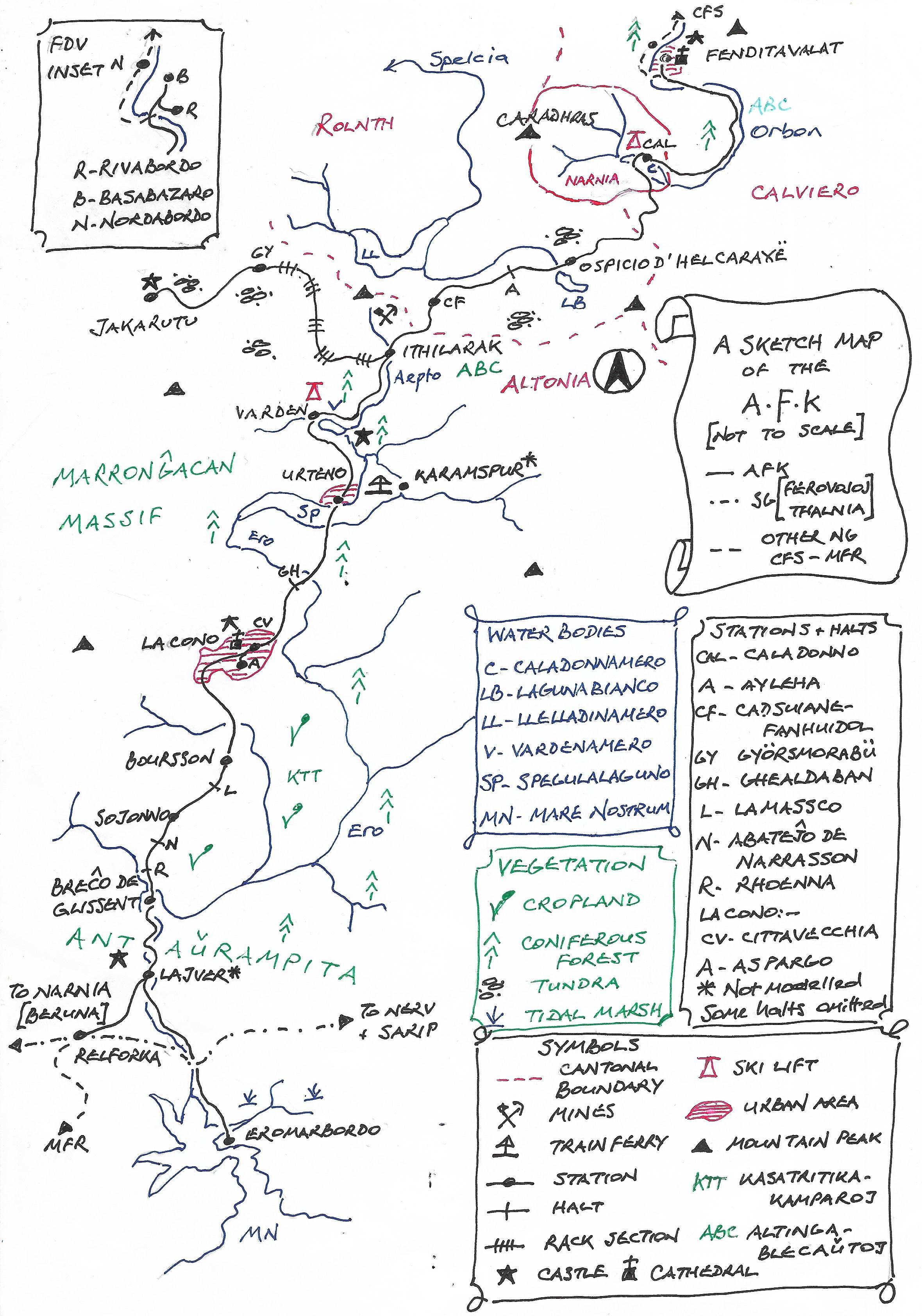
The province contains four cantons, three of which appear on the model. Each canton is based upon the catchment area of a river with the interfluves marking the cantonal boundaries. The Ero drains Altonia but the terminus at Fenditavalat, across the cantonal boundary, is drained by the Orbon. The railway briefly enters Rolnth canton as it climbs towards its summit.
Historically the area formed the Murranaccia province of the Roman empire, an almost ungovernable possession that required two permanently stationed legions to subdue it. In Mediaeval times feuding robber barons, under the nominal control of the Aŭkeratuo, the Prince-Bishop of Fenditavalat, fought over the land and its limited resources. The harsh lawlessness combined with the upland nature of the province contrived to restrict economic development. The Prince-Bishopric was amalgamated into Thalnia, as its northernmost province, during the nineteenth century nation building process. Its isolation, coupled with the depredations of two World Wars, ensure that today it remains remote, obscure and impoverished.
Thalnian railway building
In common with many nineteenth century continental countries the Thalnian railway system was determined by the military and built for strategic reasons. Franchises were awarded for each region of the country and competition was forbidden. Commercial considerations were a secondary concern. Marronĝaco was served by the Ferovojo Norda (the Northern Railway).

Map 1 The Marronĝaccan railway system
As can be seen from Map 1 the FN crossed La Kolĉeno, the narrow isthmus of land connecting Marronĝaco to the rest of the country. After reaching Nerv it took a northern course through the province meeting the Ruritanian State Railways (SRE) on neutral territory at Alligliano, in Levitheran. A later branch was constructed across the southern part of the province running to Gascari to provide a connection with the Royal Narnian Railways (KNE) through the Dorsadela Vestamontoj, the Back of the Wardrobe Mountains. This left the cities in the mountainous provincial interior unconnected to the network. Enabling legislation devolved powers for the construction of local and regional railways to the provincial assembly. These powers were intended to stimulate local economies. Unsurprisingly, given the fractious nature of the province, agreement could not be reached and the powers were handed down to the individual cantons. Eventually the AFK and the CFS were able to provide a coherent narrow gauge through route across the province, roughly at right angles to the main lines. The southern area of the province was served by the MFR, another narrow gauge line.
The geographical setting
The sketchmap (Map 2) shows the salient features of the AFK’s route. It is a rather unlikely confection in geographical terms and has been deliberately contrived to create a good mixture of traffic. The influences of the RhatischeBahn and the Roslagsbanan can easily be detected. A connection to the sea has been thrown in for good measure and the whole line has been mapped on a series of 1:50,000 scale maps, not that they are any longer shown here. The railway is effectively divided into a lowland area and a mountainous section, to be found north of Lacono, although heights are not shown on the sketch.
Map 2 The basic topography of Altonia.
The railway infrastructure of the AFK.
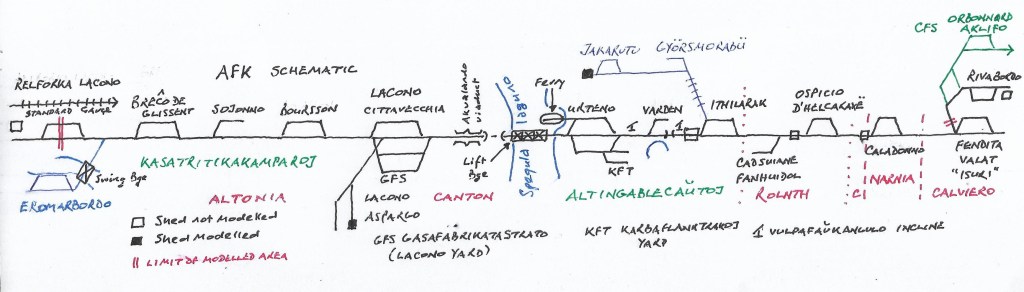
Map 3 A simplified AFK system map
Map 3 shows the basic AFK system, which is briefly summarised below.
The mainline runs for 69.5 kilometres from Relforka Lacono across the Helcaraxë Pass, where it reaches its summit at 723 metres, before dropping down to Fenditavalat. It also throws off a rack branch to Jakarutu and another to Eromarbordo.
Relforka Lacono is the junction with the standard gauge Thalnian railways. It possesses a large marshalling yard, storage sidings, a loco shed and works. These are not modelled as they would detrimentally overwhelm the layout.
The line leaves Relforka and passes Lajver before traversing the Gorge of the Ero (none of which is modelled unfortunately). Lajver is the junction for the branch to Eromarbordo, the Roman port for the province which is still commercial active.
Breĉo de Glissent marks the beginning of the Kasatritikakamparoj, an agricultural district based upon the fertile silt dropped by a periglacial lake. The line traverses a glacial trough until it reaches Boursson where it leaves the valley floor to climb into Lacono.
Lacono is the modern day provincial capital. The city contains the industrial Danulbo quarter which is a major source of traffic for the railway. There is a small marshalling yard (known as Gasafabrikatastrato or Gas Works Street) and a loco shed at Aspargo.
After leaving Lacono the line enters the mountains and crosses the Carramasco Gorge on the Akvalando viaduct before reaching Urteno.
Urteno was a historically insignificant hamlet located on an alluvial fan beside the Spegulalaguno, a ribbon lake. It developed into an upmarket tourist resort that also houses the province’s main hospital, providing much traffic for the railway. It also acts as the upper terminus for local trains traversing the lower part of the canton.
Upon exiting Urteno the route climbs into the Altingablecaŭtoj (the High Reaches) on the steeply graded vulpafaŭkangulo. Heavy trains require banking over this section.
Ithilarak stands at the top of this bank. There is a marked transition into an upland economy based upon forestry, mining and transhumance during the summer months. Ithilarak is also the junction for Jakarutu, a remote and obscure town important for its military strategic value. The railway uses the Strub rack to climb 442 metres in a distance of 14.4 kms.
The AFK proceeds to cross the cantonal boundary and enter Rolnth canton at high altitude before reaching Ospicio d’Helcaraxë, the operational summit of the line. This is a bleak snowbound area in winter but the model is shown in the “melt season”.
Trains cross the Ero/Orbon interfluve into Calviero canton and descend into a Narnian enclave at Caladonno which is modelled in permanent winter.
The line continues down the Orbon valley to reach Fenditavalat, known in Marronĝacan as Isuritakaharano, or “Isuri”. This city was the Roman provincial capital until it was usurped in modern times by Lacono. The CFS, a three phase electrified line, connects with the AFK in the Basabazaro, one of the city’s main squares to provide a connection to Krelm, on the Ruritanian mainline.
Conclusion
The basic scenario for the model has been covered, although much detail has been omitted. Hopefully I will be able to cover any relevant details as they arise.
